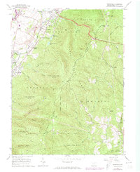
1973 Map of Brownfield
USGS Topo · Published 1973About this map
Chestnut Ridge dominates this 1973 landscape, acting as a massive geological barrier between the industrial valley settlements and the high timberlands of Forbes State Forest. The map documents a region defined by extraction and early industry, from the early iron heritage at Oliphant Furnace and Wharton Furnace to the contemporary presence of active Strip Mines. In the northwest, the suburban expansion of Hopwood, Meadowbrook, and Brownfield presses against the mountainside, while high-altitude landmarks like Laurel Caverns and the Pondfield 2 Lookout Tower provide orientation along the ridge line. The transition from rail-served heavy industry along the Penn Central and Baltimore and Ohio lines to the managed wilds of State Game Lands No 138 is clearly visible, illustrating the complex land-use patterns of Fayette County.
Find a feature on this map
63 named features on this map. Tap any name to fly to it.
Don’t see what you’re looking for? This feature index may not catch every label — zoom into the map to look around manually.
Map Details
Editions of this 1973 Brownfield Map
This is the sole edition of this map. No revisions or reprints were ever made.
Other maps of this area

1900 · Uniontown
USGS Topo · 1:62,500

1900 · Masontown
USGS Topo · 1:62,500

1902 · Morgantown
USGS Topo · 1:62,500

1903 · Masontown
USGS Topo · 1:62,500

1904 · Bruceton
USGS Topo · 1:62,500

1925 · Morgantown
USGS Topo · 1:62,500

1926 · Bruceton
USGS Topo · 1:62,500

1931 · Uniontown
USGS Topo · 1:62,500

1931 · Masontown
USGS Topo · 1:62,500

1931 · Bruceton Mills
USGS Topo · 1:62,500
Featured Places
- South Union Township, PA
- North Union Township, PA
- Meadowbrook, South Union Township
- Wharton Township, PA
- Georges Township, PA