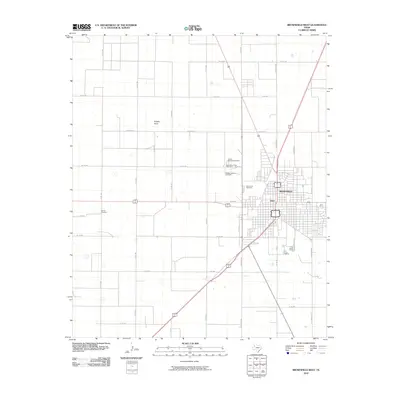
2010 Map of Brownfield West
USGS Topo · Published 2010About this map
The West Texas high plains of Terry County are defined here by the meeting of several regional thoroughfares and the modest agricultural settlement of Tokio. Just west of the larger town of Brownfield, the landscape transitions into a grid of section roads including David Bailey and Old Lamesa Rd. A cluster of burial grounds, including the New Mount Zion Cemetery, Old Mount Zion Cemetery, and County Memorial Cemetery, provides a significant point of interest for genealogists and local historians tracking family roots in the area. The topography is largely uniform, interrupted primarily by the natural drainage of Sulphur Draw. To the west, the Gomez Cemetery sits in an area otherwise dominated by large-scale agricultural parcels, illustrating the dispersed nature of rural life and memorialization in the Llano Estacado during the early 21st century.
Find a feature on this map
32 named features on this map. Tap any name to fly to it.
Don’t see what you’re looking for? This feature index may not catch every label — zoom into the map to look around manually.
Map Details
Editions of this 2010 Brownfield West Map
This is the sole edition of this map. No revisions or reprints were ever made.
Other maps of this area

1954 · Brownfield
USGS Topo · 1:250,000

1957 · Meadow
USGS Topo · 1:62,500

1958 · Brownfield
USGS Topo · 1:250,000

1962 · Brownfield
USGS Topo · 1:250,000

1969 · Brownfield East
USGS Topo · 1:24,000

1969 · Gomez
USGS Topo · 1:24,000

1969 · Foster
USGS Topo · 1:24,000

1969 · Sundown SE
USGS Topo · 1:24,000

1969 · Pool
USGS Topo · 1:24,000
1969 · Union School
USGS Topo · 1:24,000