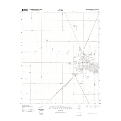
2012 Map of Brownfield West
USGS Topo · Published 2012About this map
Brownfield anchors the eastern edge of this Terry County survey, where the grid of city streets meets the expansive agricultural reaches of the High Plains. The landscape is defined by a dense network of county roads and distinctive family-named routes like David Bailey, reflecting the deep-rooted farming heritage of the region. Local history is centered around several burial grounds that reveal the community's evolution, including the County Memorial Cem, Old County Cem, and both the Old Mt Zion Cem and New Mt Zion Cem. To the west, the smaller settlement of Tokio sits near the crossing of highway routes, while the natural drainage of Sulphur Draw meanders through the northwest, and the isolated Gomez Cem stands as a quiet landmark on the western horizon.
Find a feature on this map
58 named features on this map. Tap any name to fly to it.
Don’t see what you’re looking for? This feature index may not catch every label — zoom into the map to look around manually.
Map Details
Editions of this 2012 Brownfield West Map
This is the sole edition of this map. No revisions or reprints were ever made.
Other maps of this area

1954 · Brownfield
USGS Topo · 1:250,000

1957 · Meadow
USGS Topo · 1:62,500

1958 · Brownfield
USGS Topo · 1:250,000

1962 · Brownfield
USGS Topo · 1:250,000

1969 · Brownfield East
USGS Topo · 1:24,000

1969 · Gomez
USGS Topo · 1:24,000

1969 · Foster
USGS Topo · 1:24,000

1969 · Sundown SE
USGS Topo · 1:24,000

1969 · Pool
USGS Topo · 1:24,000
1969 · Union School
USGS Topo · 1:24,000