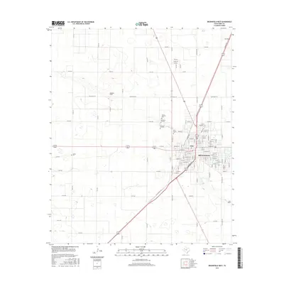
2016 Map of Brownfield West
USGS Topo · Published 2016About this map
Brownfield and the smaller settlement of Tokio anchor this West Texas landscape, where the flat plains of Terry County are bisected by significant ephemeral drainages. The local geography is defined by the paths of Sulphur Draw and Lost Draw, which carve subtle depressions through the agricultural grid. This survey reveals a concentration of communal history sites west of the main town center, particularly a cluster of cemeteries that include the County Memorial Cem, Old Mount Zion Cem, and New Mount Zion Cem. Farther west, the Gomez Cem stands alone along the section lines. The map captures the highly organized road network, from major arteries like Lubbock Rd to local routes like David Bailey Rd, illustrating how the mid-20th-century rural infrastructure evolved to support the region's scattered farmsteads and growing municipal hubs.
Find a feature on this map
114 named features on this map. Tap any name to fly to it.
Don’t see what you’re looking for? This feature index may not catch every label — zoom into the map to look around manually.
Map Details
Editions of this 2016 Brownfield West Map
This is the sole edition of this map. No revisions or reprints were ever made.
Other maps of this area

1954 · Brownfield
USGS Topo · 1:250,000

1957 · Meadow
USGS Topo · 1:62,500

1958 · Brownfield
USGS Topo · 1:250,000

1962 · Brownfield
USGS Topo · 1:250,000

1969 · Brownfield East
USGS Topo · 1:24,000

1969 · Gomez
USGS Topo · 1:24,000

1969 · Foster
USGS Topo · 1:24,000

1969 · Sundown SE
USGS Topo · 1:24,000

1969 · Pool
USGS Topo · 1:24,000
1969 · Union School
USGS Topo · 1:24,000