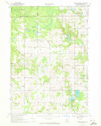
1969 Map of Browns Corners
USGS Topo · Published 1972About this map
The Middle Branch Tobacco River and its northern counterpart wind through this central Michigan landscape, defining the rural character of the Arthur and Sheridan townships. At the time of this 1969 field check, the region was characterized by scattered farmsteads and small crossroads like Browns Corners and Dover. A remnant of earlier industrial logistics is visible in the Old Railroad Grade cutting across the northern sections, while the local social fabric is traced through landmarks like Arthur Center Sch and St Johns Ch. Significant portions of the northwest are dedicated to the Chippewa River State Forest, preserving the wooded wetlands around Lily Lake and Upper Brennan Lake. The presence of several family-named burial grounds, including Ott Cem and Wood Cem, provides essential points of interest for genealogists mapping the early families of Clare County.
Find a feature on this map
52 named features on this map. Tap any name to fly to it.
Don’t see what you’re looking for? This feature index may not catch every label — zoom into the map to look around manually.
Map Details
Editions of this 1969 Browns Corners Map
2 editions found
Other maps of this area

1954 · Traverse City
USGS Topo · 1:250,000

1954 · Midland
USGS Topo · 1:250,000

1957 · Harrison
USGS Topo · 1:62,500

1958 · Traverse City
USGS Topo · 1:250,000

1958 · Midland
USGS Topo · 1:250,000

1959 · Midland
USGS Topo · 1:250,000

1959 · Clare
USGS Topo · 1:62,500

1966 · Midland
USGS Topo · 1:250,000

1969 · Meredith SW
USGS Topo · 1:24,000

1969 · Coleman
USGS Topo · 1:24,000