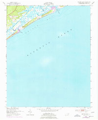
1952 Map of Browns Inlet
USGS Topo · Published 1977About this map
The Camp Lejeune Military Reservation dominates this coastal landscape, reflecting the heavy military presence in Onslow County during the mid-20th century. This 1952 topographic study, with revisions through the early 1970s, captures the complex shoreline and marshlands where the Intracoastal Waterway cuts behind the barrier islands. Small coastal points such as Still, Eagle, and Brown are identified alongside Cedar, providing specific geographic markers for local family names and small landing sites. The dynamic nature of the Outer Banks is visible through the Shifting Sand Dunes at Bear Inlet, some reaching fifteen feet in elevation. Navigational features like the Banks Channel and Sanders Creek illustrate the maritime routes used by vessels navigating Onslow Bay. The map reveals a balance between the vastness of the Atlantic Ocean and the intricate, tide-influenced backwaters of Browns Inlet.
Find a feature on this map
23 named features on this map. Tap any name to fly to it.
Don’t see what you’re looking for? This feature index may not catch every label — zoom into the map to look around manually.
Map Details
Editions of this 1952 Browns Inlet Map
5 editions found
Other maps of this area

1942 · Spicer Bay
USGS Topo · 1:62,500

1942 · Swansboro
USGS Topo · 1:62,500

1948 · Swansboro
USGS Topo · 1:62,500

1948 · New River
USGS Topo · 1:62,500

1952 · Hubert
USGS Topo · 1:24,000

1952 · Camp Lejeune
USGS Topo · 1:24,000

1952 · Swansboro
USGS Topo · 1:24,000

1952 · Browns Inlet
USGS Topo · 1:24,000

1952 · New River Inlet
USGS Topo · 1:24,000

1953 · Beaufort
USGS Topo · 1:250,000