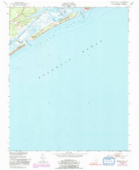
1952 Map of Browns Inlet
USGS Topo · Published 1991About this map
Camp Lejeune Military Reservation dominates the coastal landscape in this mid-century survey of the North Carolina shoreline. The map documents a complex maritime environment where the Intracoastal Waterway cuts behind the barrier islands, maintained at a Project Depth 12 Feet for coastal navigation. This is a landscape of shifting sands and tidal transition, evidenced by the migratory Shifting Sand Dunes and various deep-water access points like Browns Inlet and Bear Inlet.
Find a feature on this map
25 named features on this map. Tap any name to fly to it.
Don’t see what you’re looking for? This feature index may not catch every label — zoom into the map to look around manually.
Map Details
Editions of this 1952 Browns Inlet Map
5 editions found
Other maps of this area

1942 · Spicer Bay
USGS Topo · 1:62,500

1942 · Swansboro
USGS Topo · 1:62,500

1948 · Swansboro
USGS Topo · 1:62,500

1948 · New River
USGS Topo · 1:62,500

1952 · Hubert
USGS Topo · 1:24,000

1952 · Camp Lejeune
USGS Topo · 1:24,000

1952 · Swansboro
USGS Topo · 1:24,000

1952 · Browns Inlet
USGS Topo · 1:24,000

1952 · New River Inlet
USGS Topo · 1:24,000

1953 · Beaufort
USGS Topo · 1:250,000