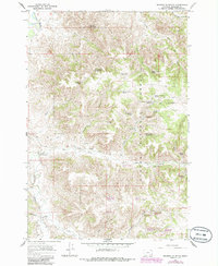
1966 Map of Browns Mountain
USGS Topo · Published 1986About this map
The Tongue River cuts through the northwest corner of this landscape, where a footbridge once provided local access near the river's edge. Much of the terrain is defined by the high elevations of Browns Mountain and the expansive reaches of the Custer National Forest. The map documents a sparsely populated ranching country during the mid-1960s, evidenced by isolated holdings like Bones Ranch, Gilliland Ranch, and Daniels Ranch. These homesteads were supported by a complex network of springs and man-made water improvements, such as the Brewster Gulch Corral Well and Timber Creek Basin Reservoir. The drainage patterns of Hanging Woman Creek and Lee Creek illustrate the geographical challenges of the region, while the presence of a Landing Area suggests the importance of light aircraft for managing these remote Montana rangelands before modern infrastructure reached the interior.
Find a feature on this map
49 named features on this map. Tap any name to fly to it.
Don’t see what you’re looking for? This feature index may not catch every label — zoom into the map to look around manually.
Map Details
Editions of this 1966 Browns Mountain Map
2 editions found
Other maps of this area

1954 · Hardin
USGS Topo · 1:250,000

1957 · Hardin
USGS Topo · 1:250,000

1958 · Hardin
USGS Topo · 1:250,000

1966 · Browns Mountain
USGS Topo · 1:24,000

1966 · Birney Day School
USGS Topo · 1:24,000

1966 · Poker Jim Butte
USGS Topo · 1:24,000
1966 · Green Creek
USGS Topo · 1:24,000

1967 · Clubfoot Creek
USGS Topo · 1:24,000

1967 · Birney
USGS Topo · 1:24,000

1967 · Lacey Gulch
USGS Topo · 1:24,000