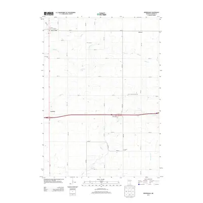
2013 Map of Brownsdale
USGS Topo · Published 2013About this map
Brownsdale serves as the primary hub in this portion of Mower County, situated at the junction of MN-56 and E Main St. The surrounding landscape is defined by a grid of agricultural roads and several significant drainage systems, including Wolf Cr, Dobbins Cr, and the Little Cedar River. Smaller settlements like Renova and Nicolville are positioned along these corridors, providing a glimpse into the localized development of the region.
Find a feature on this map
36 named features on this map. Tap any name to fly to it.
Don’t see what you’re looking for? This feature index may not catch every label — zoom into the map to look around manually.
Map Details
Editions of this 2013 Brownsdale Map
This is the sole edition of this map. No revisions or reprints were ever made.
Other maps of this area

1954 · Austin
USGS Topo · 1:62,500

1954 · Mason City
USGS Topo · 1:250,000

1955 · High Forest
USGS Topo · 1:62,500

1957 · Mason City
USGS Topo · 1:250,000

1958 · Mason City
USGS Topo · 1:250,000

1965 · Dexter
USGS Topo · 1:24,000

1965 · Adams
USGS Topo · 1:24,000

1966 · Waltham
USGS Topo · 1:24,000

1966 · Sargeant
USGS Topo · 1:24,000
1974 · High Forest SW
USGS Topo · 1:24,000