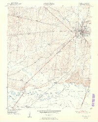
1951 Map of Brownsville
USGS Topo · Published 1951About this map
Brownsville serves as the focal point for this mid-century topographic study, radiating infrastructure into the surrounding West Tennessee landscape. The town is marked by institutional landmarks such as the County High Sch and the County Fairgrounds, while the surrounding countryside is dotted with rural centers like Sunnyhill and the rail-dependent Shepp (Shepards Sta). Transportation corridors define the region's economy, specifically the Louisville and Nashville railroad and the Broadway of America highway crossing the terrain. To the south, the Hatchie River meanders through the broad Hatchie Bottom, a wetland landscape filled with numerous oxbow lakes such as Moon Lake, Horseshoe Lake, and Jacks Lake. This area reveals a dense network of early 20th-century social structures, including numerous schools like Macedonia Sch and Cuthbert Switch Sch, and churches like Lebanon Ch, reflecting the dispersed settlement patterns of the era.
Find a feature on this map
48 named features on this map. Tap any name to fly to it.
Don’t see what you’re looking for? This feature index may not catch every label — zoom into the map to look around manually.
Map Details
Editions of this 1951 Brownsville Map
3 editions found
Other maps of this area

1950 · Sunnyhill
USGS Topo · 1:24,000

1950 · Brownsville
USGS Topo · 1:24,000

1951 · Brownsville
USGS Topo · 1:24,000

1951 · Sunnyhill
USGS Topo · 1:24,000

1952 · Stanton
USGS Topo · 1:24,000

1952 · Dancyville
USGS Topo · 1:24,000

1952 · Stanton
USGS Topo · 1:62,500

1956 · Blytheville
USGS Topo · 1:250,000

1959 · Blytheville
USGS Topo · 1:250,000

1959 · Hillville
USGS Topo · 1:24,000