
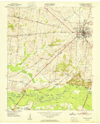
1951 Map of Brownsville
USGS Topo · Published 1951About this map
Brownsville serves as the focal point for this West Tennessee survey, established as a major junction for the Louisville and Nashville railroad and historic thoroughfares like the Old Turnpike and the Broadway of America. The town's social fabric is visible through landmarks such as the County High Sch and the County Fairgrounds, while surrounding rural life centers on scattered institutions including Patton Sch and Lebanon Ch.
Find a feature on this map
48 named features on this map. Tap any name to fly to it.
Don’t see what you’re looking for? This feature index may not catch every label — zoom into the map to look around manually.
Map Details
Editions of this 1951 Brownsville Map
3 editions found
Other maps of this area

1950 · Sunnyhill
USGS Topo · 1:24,000

1950 · Brownsville
USGS Topo · 1:24,000

1951 · Sunnyhill
USGS Topo · 1:24,000

1952 · Stanton
USGS Topo · 1:24,000

1952 · Dancyville
USGS Topo · 1:24,000

1952 · Stanton
USGS Topo · 1:62,500

1956 · Blytheville
USGS Topo · 1:250,000

1959 · Blytheville
USGS Topo · 1:250,000

1959 · Hillville
USGS Topo · 1:24,000

1961 · Jones
USGS Topo · 1:24,000