
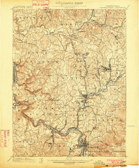
1902 Map of Brownsville
USGS Topo · Published 1902About this map
The Monongahela River carves a deep, winding industrial corridor through the heart of this turn-of-the-century landscape, flanked by bustling river towns and active mining operations. This era of heavy production is evident in the concentration of riverside settlements like Charleroi, Monessen, and Monongahela, which relied on the Pittsburg & Lake Erie RR and the Pennsylvania RR for transport. Industry and geology meet at sites like Vesta Mine and Black Diamond, while the ancient transit route of the National Pike cuts across the southern portion of the sheet near Brownsville.
Find a feature on this map
150 named features on this map. Tap any name to fly to it.
Don’t see what you’re looking for? This feature index may not catch every label — zoom into the map to look around manually.
Map Details
Editions of this 1902 Brownsville Map
This is the sole edition of this map. No revisions or reprints were ever made.
Other maps of this area

1900 · Uniontown
USGS Topo · 1:62,500

1900 · Masontown
USGS Topo · 1:62,500

1901 · Amity
USGS Topo · 1:62,500

1901 · Waynesburg
USGS Topo · 1:62,500
1902 · Connellsville
USGS Topo · 1:62,500

1903 · Masontown
USGS Topo · 1:62,500

1904 · Amity
USGS Topo · 1:62,500

1904 · Mc Keesport
USGS Topo · 1:62,500

1904 · Waynesburg
USGS Topo · 1:62,500

1904 · Carnegie
USGS Topo · 1:62,500