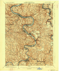
1933 Map of Brownsville
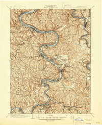
USGS Topo · Published 1945About this map
The Monongahela River and Youghiogheny River dominate this industrial landscape, where steep valleys are carved by dozens of runs and creeks. The riverfronts are densely populated with small coal and steel settlements including Webster, Sutersville, and Hiller. Infrastructure for the region's extraction economy is visible in features like the Vesta Mine, Colonial Dock, and the strategic Lock No 4 and Lock No 5. Away from the riverbanks, the National Pike cuts across the southern portion of the sheet, connecting older rural communities and landmarks such as Quaker Ch and Salem Church. The map illustrates the intense intersection of river navigation, multiple rail lines like the Pittsburgh & Lake Erie RR, and the topographical constraints that shaped Western Pennsylvania’s industrial expansion in the early twentieth century.
Find a feature on this map
148 named features on this map. Tap any name to fly to it.
Don’t see what you’re looking for? This feature index may not catch every label — zoom into the map to look around manually.
Map Details
Editions of this 1933 Brownsville Map
2 editions found

Historical Maps of Monessen Through Time
5 maps found