
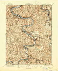
1933 Map of Brownsville
USGS Topo · Published 1933About this map
The industrial corridor of the Monongahela Valley is captured in detail as coal and steel drove the regional economy during the early 1930s. Tight bends of the Monongahela River are lined with coal-patch towns and industrial hubs like Monessen, Donora, and Charleroi, while the river itself serves as a major transit artery alongside the Pittsburgh & Lake Erie RR. The landscape is a dense network of family-named settlements and industrial sites, including the Vesta Mine and evocative place names such as Coal Bluff and Black Diamond.
Find a feature on this map
147 named features on this map. Tap any name to fly to it.
Don’t see what you’re looking for? This feature index may not catch every label — zoom into the map to look around manually.
Map Details
Editions of this 1933 Brownsville Map
2 editions found
Other maps of this area

1900 · Uniontown
USGS Topo · 1:62,500

1900 · Masontown
USGS Topo · 1:62,500

1901 · Amity
USGS Topo · 1:62,500

1901 · Waynesburg
USGS Topo · 1:62,500

1902 · Brownsville
USGS Topo · 1:62,500

1902 · Connellsville
USGS Topo · 1:62,500

1903 · Masontown
USGS Topo · 1:62,500

1904 · Amity
USGS Topo · 1:62,500

1904 · Mc Keesport
USGS Topo · 1:62,500

1904 · Waynesburg
USGS Topo · 1:62,500