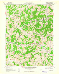
1961 Map of Brownton
USGS Topo · Published 1962About this map
Coal extraction dominates the landscape of this Barbour County region, where Strip Mines and industrial infrastructure like the Tipple and Conveyor are etched into the hills surrounding Brownton. The Baltimore and Ohio railroad follows the valley of Elk Creek, serving a network of mines and settlements including Galloway and Astor. This 1961 field check captures a community in transition, balancing heavy industry with rural landmarks like the Covered Bridge on Brushy Fork. Local social centers are well-documented through country schools like Mt Vernon Sch and churches such as Trinity Ch and Green Hill Ch. The map provides a detailed look at the interface between the narrow creek bottoms and the heights of Bear Mountain, tracing the complex road and rail network required to move West Virginia coal to market.
Find a feature on this map
44 named features on this map. Tap any name to fly to it.
Don’t see what you’re looking for? This feature index may not catch every label — zoom into the map to look around manually.
Map Details
Editions of this 1961 Brownton Map
3 editions found
Other maps of this area

1902 · Clarksburg
USGS Topo · 1:62,500

1902 · Fairmont
USGS Topo · 1:62,500

1904 · Philippi
USGS Topo · 1:62,500

1904 · Weston
USGS Topo · 1:62,500

1910 · Clarksburg
USGS Topo · 1:62,500

1923 · Fairmont
USGS Topo · 1:62,500

1923 · Clarksburg
USGS Topo · 1:62,500

1925 · Clarksburg
USGS Topo · 1:62,500

1925 · Philippi
USGS Topo · 1:62,500

1926 · Fairmont
USGS Topo · 1:62,500