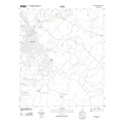
2010 Map of Brownwood
USGS Topo · Published 2010About this map
Brownwood and the neighboring city of Early anchor this landscape during a period of sustained growth in Central Texas. The urban core is defined by the campus of Howard Payne University and the historic Greenleaf Cemetery, while residential expansion pushes south toward Woodland Heights. The map reveals a complex water management system engineered to support the region's agricultural and municipal needs, featuring the Municipal Reservoir Upper Dam on Pecan Bayou and several specialized reservoirs like the Soil Conservation Service Site 4a Reservoir. These man-made features interact with the natural drainage of Adams Branch and Willis Creek. To the north, the US Agricultural Experiment signifies the area's long-standing connection to land use research, while family-named sites such as Connell Cemetery and Beairds Cemetery provide essential touchstones for genealogical research in this part of Brown County.
Find a feature on this map
53 named features on this map. Tap any name to fly to it.
Don’t see what you’re looking for? This feature index may not catch every label — zoom into the map to look around manually.
Map Details
Editions of this 2010 Brownwood Map
This is the sole edition of this map. No revisions or reprints were ever made.
Other maps of this area

1887 · Coleman
USGS Topo · 1:125,000

1889 · Brownwood
USGS Topo · 1:125,000

1889 · Coleman
USGS Topo · 1:125,000

1894 · Brownwood
USGS Topo · 1:125,000

1924 · Brownwood Reservoir Site
USGS Topo · 1:48,000

1925 · Brownwood 3-b
USGS Topo · 1:48,000

1925 · Brownwood 3-d
USGS Topo · 1:48,000

1927 · Grosvenor
USGS Topo · 1:62,500

1928 · Zephyr
USGS Topo · 1:62,500

1950 · Zephyr
USGS Topo · 1:62,500