
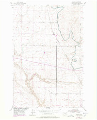
1954 Map of Bruce
USGS Topo · Published 1955About this map
Northern Pacific rail lines dominate the agricultural landscape of this central Washington plateau, connecting the rural sidings of Bruce and Koren. The infrastructure of the Columbia Basin Project is evident through the winding path of the East Low Canal, which utilizes a series of embankments and the Kansas Prairie Siphon to navigate the undulating terrain. To the south, the broad expanse of Paradise Flats transitions into a complex of coulees and breaks. Small-scale industrial and agricultural markers, including a Quarry, a Water Tank, and a scattered Windmill, reveal a landscape undergoing transformation through large-scale irrigation and railway transport during the mid-1950s.
Find a feature on this map
15 named features on this map. Tap any name to fly to it.
Don’t see what you’re looking for? This feature index may not catch every label — zoom into the map to look around manually.
Map Details
Editions of this 1954 Bruce Map
2 editions found
Other maps of this area

1916 · Connell
USGS Topo · 1:125,000

1918 · Connell
USGS Topo · 1:125,000

1924 · Othello
USGS Topo · 1:62,500

1925 · Scooteney Lake
USGS Topo · 1:62,500

1951 · Scooteney Lake
USGS Topo · 1:62,500

1953 · Walla Walla
USGS Topo · 1:250,000

1954 · Warden
USGS Topo · 1:24,000

1954 · Soda Lake
USGS Topo · 1:24,000

1954 · Othello
USGS Topo · 1:24,000

1954 · Othello
USGS Topo · 1:62,500