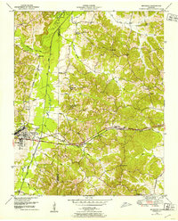
1950 Map of Bruceton
USGS Topo · Published 1953About this map
Bruceton serves as the central hub of this 1950s survey, defined by the convergence of the Nashville Chattanooga and St Louis railway and major early thoroughfares like Broadway and America. The landscape is characterized by an extensive system of man-made water management, including the Martin Drainage Canal and Lick Drainage Canal, which altered the natural flow of the Big Sandy River to support agricultural development. Small rural communities and stops such as Sawyers Mill, Lipe, and Britton are scattered along the rail line and creek valleys.
Find a feature on this map
42 named features on this map. Tap any name to fly to it.
Don’t see what you’re looking for? This feature index may not catch every label — zoom into the map to look around manually.
Map Details
Editions of this 1950 Bruceton Map
3 editions found
Other maps of this area

1936 · Camden
USGS Topo · 1:24,000

1936 · Seventeen Creek
USGS Topo · 1:24,000

1936 · Big Sandy
USGS Topo · 1:24,000

1936 · Mansfield
USGS Topo · 1:24,000

1936 · Vale
USGS Topo · 1:24,000

1936 · Bruceton
USGS Topo · 1:24,000

1936 · Buena Vista
USGS Topo · 1:24,000

1936 · Rockport
USGS Topo · 1:24,000

1936 · Manleyville
USGS Topo · 1:24,000

1940 · Manleyville
USGS Topo · 1:24,000