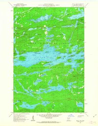
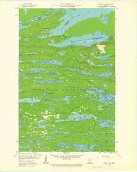
1960 Map of Brule Lake
USGS Topo · Published 1963About this map
The Misquah Hills overlook a dense network of glacial lakes and portages in this 1960 survey of Cook County. Situated within the Superior National Forest and Minnesota State Forest, the landscape is dominated by the expansive waters of Brule Lake, featuring distinct landmarks such as Fishbox Island, Jock Mock Point, and Brule Island. This survey captures the wilderness character of the Boundary Waters region before later management changes, showing a solitary Campground and the Brule Lake Lookout Tower as the primary points of human infrastructure. The map provides depth curves for the major water bodies, including Winchell Lake and Wanihigan Lake, alongside smaller isolated waters like Trump Lake and Cash Lake. A single unimproved dirt road provides the only vehicle access into this remote aquatic terrain.
Find a feature on this map
56 named features on this map. Tap any name to fly to it.
Don’t see what you’re looking for? This feature index may not catch every label — zoom into the map to look around manually.
Map Details
Editions of this 1960 Brule Lake Map
5 editions found

Other maps of this area

1919 · Brule Lake
USGS Topo · 1:62,500

1954 · Two Harbors
USGS Topo · 1:250,000

1957 · Two Harbors
USGS Topo · 1:250,000

1957 · Quetico
USGS Topo · 1:250,000

1958 · Two Harbors
USGS Topo · 1:250,000

1960 · Tait Lake
USGS Topo · 1:24,000

1960 · Mark Lake
USGS Topo · 1:24,000
1960 · South Lake
USGS Topo · 1:24,000

1960 · Sawbill Camp
USGS Topo · 1:24,000
1960 · Eagle Mountain
USGS Topo · 1:24,000