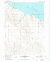
1971 Map of Brule NE
USGS Topo · Published 1974About this map
Lake McConaughy dominates the northern reaches of this Keith County landscape, where the waters of the North Platte River are impounded. The terrain is defined by a series of deep drainage features cutting through the high plains toward the shoreline, including Ash Camp Canyon, O'Brien Canyon, and Kelly Canyon. This early 1970s survey illustrates the intersection of natural topography and mid-century recreation, specifically at the Lake McConaughy Landing Strip and the nearby Campground. The map provides specific detail on the upland breaks, where Berry Gulch and Ogallala Gulch carve into the plateau south of the reservoir. A small Trailer Park near the water's edge reflects the seasonal and residential development that followed the creation of the lake.
Find a feature on this map
11 named features on this map. Tap any name to fly to it.
Don’t see what you’re looking for? This feature index may not catch every label — zoom into the map to look around manually.
Map Details
Editions of this 1971 Brule NE Map
This is the sole edition of this map. No revisions or reprints were ever made.
Other maps of this area

1897 · Ogallala
USGS Topo · 1:125,000

1900 · Ogallala
USGS Topo · 1:125,000

1954 · North Platte
USGS Topo · 1:250,000

1956 · North Platte
USGS Topo · 1:250,000

1957 · North Platte
USGS Topo · 1:250,000
1961 · Brule
USGS Topo · 1:24,000
1961 · Brule SE
USGS Topo · 1:24,000

1967 · North Platte
USGS Topo · 1:250,000

1971 · Martin
USGS Topo · 1:24,000
1971 · Brule NW
USGS Topo · 1:24,000