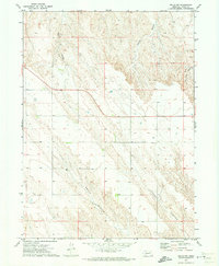
1971 Map of Brule NW
USGS Topo · Published 1973About this map
Deep-cut drainage systems define this high plains landscape in Keith County, where Brule Canyon and Chase Canyon converge toward the south. The 1971 survey shows a sparsely populated ranching or farming region marked by a network of unimproved roads and fine dashed lines indicating field and fence boundaries. A single center of local community activity is represented by School No 46, situated on the plateau between major canyon systems. Other notable geographic features include Eagle Canyon, Coyote Canyon, and Ash Camp Canyon, which carve through the terrain. Evidence of water management in this arid environment is limited to isolated features like a Well located in the western portion of the quadrangle. The topography reflects the complex erosional patterns typical of the Nebraska panhandle region during this era.
Find a feature on this map
7 named features on this map. Tap any name to fly to it.
Don’t see what you’re looking for? This feature index may not catch every label — zoom into the map to look around manually.
Map Details
Editions of this 1971 Brule NW Map
This is the sole edition of this map. No revisions or reprints were ever made.
Other maps of this area

1897 · Ogallala
USGS Topo · 1:125,000

1900 · Chappell
USGS Topo · 1:125,000

1900 · Ogallala
USGS Topo · 1:125,000

1954 · Scottsbluff
USGS Topo · 1:250,000

1954 · North Platte
USGS Topo · 1:250,000

1956 · North Platte
USGS Topo · 1:250,000

1957 · North Platte
USGS Topo · 1:250,000

1958 · Scottsbluff
USGS Topo · 1:250,000

1961 · Big Springs
USGS Topo · 1:24,000
1961 · Brule
USGS Topo · 1:24,000