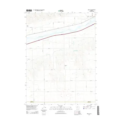
2014 Map of Brule SE
USGS Topo · Published 2014About this map
The South Platte River and its accompanying irrigation infrastructure define this agricultural landscape on the border of Keith and Perkins Counties. The Western Canal winds through the southern uplands, supporting the Western Irrigation District Reservoir, a testament to the region's managed water resources. To the north, the river corridor serves as a primary transportation artery, where Us-30 and the railroad parallel the water's edge, connecting the small aviation hubs of Searle Field and the more remote Shelburnes Airport. The terrain transitions from the river valley floor to the dissected breaks of Chase Canyon, while a dense grid of rural roads like Sunny Slope Rd and Airport Rd provides access to the surrounding farmsteads and rangeland.
Find a feature on this map
25 named features on this map. Tap any name to fly to it.
Don’t see what you’re looking for? This feature index may not catch every label — zoom into the map to look around manually.
Map Details
Editions of this 2014 Brule SE Map
This is the sole edition of this map. No revisions or reprints were ever made.
Other maps of this area
1897 · Ogallala
USGS Topo · 1:125,000
1900 · Ogallala
USGS Topo · 1:125,000
1954 · McCook
USGS Topo · 1:250,000
1954 · North Platte
USGS Topo · 1:250,000
1956 · North Platte
USGS Topo · 1:250,000
1957 · North Platte
USGS Topo · 1:250,000
1957 · McCook
USGS Topo · 1:250,000
1958 · McCook
USGS Topo · 1:250,000
1961 · Brandon NE
USGS Topo · 1:24,000
1961 · Brandon NW
USGS Topo · 1:24,000