
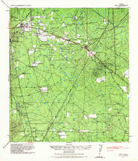
1939 Map of Bruni
USGS Topo · Published 1958About this map
Oil and cattle define this South Texas landscape at the end of the 1930s, where the Texas Mexican railroad cuts a diagonal path through the brush country. The energy industry is heavily represented by the massive OW Killam Refinery (Amsco) near Mirando City and the Valdez Oil Field, supported by an intricate network of infrastructure including the Magnolia Pipeline Company (Oil) and Humble Pipe Line Company (Oil).
Find a feature on this map
49 named features on this map. Tap any name to fly to it.
Don’t see what you’re looking for? This feature index may not catch every label — zoom into the map to look around manually.
Map Details
Editions of this 1939 Bruni Map
2 editions found
Other maps of this area

1937 · Aguilete Creek
USGS Topo · 1:62,500

1939 · Randado
USGS Topo · 1:62,500

1940 · Aguilares
USGS Topo · 1:62,500

1940 · Randado
USGS Topo · 1:62,500

1940 · Mogotes Hill
USGS Topo · 1:62,500

1956 · Mogotes Hill
USGS Topo · 1:62,500

1956 · Laredo
USGS Topo · 1:250,000

1967 · Hebbronville NW
USGS Topo · 1:24,000

1967 · Hebbronville
USGS Topo · 1:24,000

1968 · Parrilla Creek SW
USGS Topo · 1:24,000