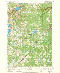
1962 Map of Bruno
USGS Topo · Published 1970About this map
Great Northern and Soo Line tracks converge and parallel one another as they travel through the forest and lake country of Pine and Carlton counties. This 1962 field-checked survey highlights the rail-dependent corridor of small towns like Bruno, Kerrick, Duquette, and Nickerson, which are strung along the tracks like beads. The landscape is defined by its glacial history, featuring an abundance of water bodies including Hanging Horn Lake, Sturgeon Lake, and Moose Lake. These lakes are accompanied by recreational and community landmarks such as Moose Lake Camp, Camp Wanakiawin, and even a Drive-in Theater near Barnum. To the east, the Nemadji State Forest dominates the terrain, where the Nickerson Lookout Tower stands as a sentinel over the dense woodland. Local genealogy is well-supported by numerous burial sites including St Michaels Cem, Bruno Cem, and Riverside Cem.
Find a feature on this map
70 named features on this map. Tap any name to fly to it.
Don’t see what you’re looking for? This feature index may not catch every label — zoom into the map to look around manually.
Map Details
Editions of this 1962 Bruno Map
2 editions found

Other maps of this area

1949 · Danbury
USGS Topo · 1:48,000

1949 · Holyoke
USGS Topo · 1:48,000

1953 · Duluth
USGS Topo · 1:250,000

1954 · Wrenshall
USGS Topo · 1:24,000

1954 · Atkinson
USGS Topo · 1:24,000

1956 · Barnum
USGS Topo · 1:62,500

1958 · Duluth
USGS Topo · 1:250,000

1961 · Sandstone
USGS Topo · 1:62,500

1961 · Cromwell
USGS Topo · 1:62,500

1961 · Moose Lake
USGS Topo · 1:62,500