
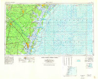
1956 Map of Brunswick
USGS Topo · Published 1968About this map
Brunswick serves as the coastal anchor for this detailed mid-century survey, a period when the Georgia coastline was defined by its vast maritime forests, river deltas, and significant military footprints. The landscape is a complex network of sounds and islands, from Ossabaw Island in the north to Jekyll Island in the south, separated from the mainland by the massive Altamaha River delta and Big Cypress Swamp. This era shows the extensive reaches of the Fort Stewart Military Reservation and Hunter Air Force Base, reflecting the strategic importance of the Atlantic seaboard during the Cold War.
Find a feature on this map
169 named features on this map. Tap any name to fly to it.
Don’t see what you’re looking for? This feature index may not catch every label — zoom into the map to look around manually.
Map Details
Editions of this 1956 Brunswick Map
2 editions found
Other maps of this area

1917 · Nahunta
USGS Topo · 1:62,500

1917 · Boulogne
USGS Topo · 1:62,500

1918 · Cumberland Island
USGS Topo · 1:62,500

1918 · Jesup
USGS Topo · 1:62,500

1918 · Folkston
USGS Topo · 1:62,500

1918 · Hortense
USGS Topo · 1:62,500

1918 · Hinesville
USGS Topo · 1:62,500

1918 · Everett City
USGS Topo · 1:62,500

1918 · Nahunta
USGS Topo · 1:62,500

1918 · Bladen
USGS Topo · 1:62,500