Loading...
Loading map...1956 Map of Brunswick
USGS Topo · Published 1978About this map
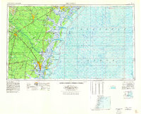
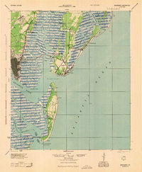
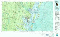
Brunswick and the Georgia coastline serve as the centerpiece of this mid-century coastal study, revealing a complex network of barrier islands and tidal sounds. The geography is defined by the massive Fort Stewart Military Reservation to the north and the intricate drainage of the Altamaha River, which separates McIntosh County from Glynn County. The map details the transition from the inland pine forests and swamps like Big Cypress Swamp to the developed maritime centers and protected wilderness areas.
Find a feature on this map
110 named features on this map. Tap any name to fly to it.
Don’t see what you’re looking for? This feature index may not catch every label — zoom into the map to look around manually.
Map Details
Date Portrayed1956
Date Published1978
PublisherU.S. Geological Survey
Map TypeTopographic
Scale1:250,000
Physical Dimensions33.9 x 27.5 inches
Editions of this 1956 Brunswick Map
2 editions found

Historical Maps of Savannah Through Time
7 maps found


Featured Locations
Source Details
SourceU.S. Geological Survey
CopyrightPublic Domain