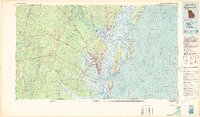
1981 Map of Brunswick
USGS Topo · Published 1982About this map
Coastal Georgia's intricate network of barrier islands and tidal marshes defines this 1981 survey, where the Altamaha River and Satilla River reach the Atlantic. The city of Brunswick serves as a central hub, connected to the mainland and the popular Golden Isles by a series of causeways and bridges. This edition provides an important look at the region's conservation landscape, marking the expansive Wolf Island National Wildlife Refuge and Wilderness Area and the Sapelo Island National Estuarine Sanctuary.
Find a feature on this map
99 named features on this map. Tap any name to fly to it.
Don’t see what you’re looking for? This feature index may not catch every label — zoom into the map to look around manually.
Map Details
Editions of this 1981 Brunswick Map
3 editions found
Other maps of this area

1917 · Nahunta
USGS Topo · 1:62,500

1917 · Boulogne
USGS Topo · 1:62,500

1918 · Cumberland Island
USGS Topo · 1:62,500

1918 · Jesup
USGS Topo · 1:62,500

1918 · Folkston
USGS Topo · 1:62,500

1918 · Hortense
USGS Topo · 1:62,500

1918 · Everett City
USGS Topo · 1:62,500

1918 · Nahunta
USGS Topo · 1:62,500

1918 · Bladen
USGS Topo · 1:62,500

1918 · Kingsland
USGS Topo · 1:62,500