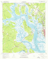
1956 Map of Brunswick West
USGS Topo · Published 1976About this map
The Turtle River and South Brunswick River converge in this mid-century survey of the Georgia coast, revealing a landscape defined by intricate tidal waterways and low-lying marsh islands. Near the town of Arco, the industrial and transportation footprint is evident through the convergence of the Southern and Atlantic Coast Line railroads at Southern Junction. The maritime character of Glynn County is centered on the Blythe Island Naval Reservation, situated among a complex network of channels including Ratcliffe Slough and Morrison Slough. Local community life is marked by numerous country churches such as Springfield Ch and Emanuel Ch, while the eastern edge captures the growth of Brunswick and the established grounds of Palmetto Cemetery. The map documents a period before modern coastal development reshaped these marshes, preserving the locations of early landmarks like Fancy Bluff and Maggie Hummocks.
Find a feature on this map
52 named features on this map. Tap any name to fly to it.
Don’t see what you’re looking for? This feature index may not catch every label — zoom into the map to look around manually.
Map Details
Editions of this 1956 Brunswick West Map
2 editions found
Other maps of this area

1918 · Everett City
USGS Topo · 1:62,500

1918 · Bladen
USGS Topo · 1:62,500

1920 · Everett City
USGS Topo · 1:62,500

1921 · Darien
USGS Topo · 1:62,500

1939 · Bladen
USGS Topo · 1:62,500

1944 · Everett City
USGS Topo · 1:62,500

1945 · Brunswick
USGS Topo · 1:62,500

1946 · Brunswick
USGS Topo · 1:250,000

1948 · Brunswick
USGS Topo · 1:250,000
1956 · Bladen
USGS Topo · 1:24,000