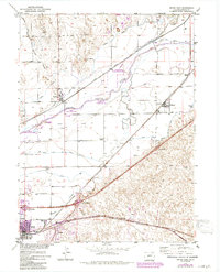
1971 Map of Brush East
USGS Topo · Published 1984About this map
The South Platte River corridor dominates this landscape, serving as a vital artery for both nature and industry in Morgan County. The river valley is flanked by a series of conservation zones, including the Cottonwood State Wildlife Area and South Platte State Wildlife Area, which underscore the region's importance as a riparian habitat. Economic activity centers on the river's resources, evidenced by the Lower Platte and Beaver Canal and a large Sugar Refinery near the town of Brush.
Find a feature on this map
31 named features on this map. Tap any name to fly to it.
Don’t see what you’re looking for? This feature index may not catch every label — zoom into the map to look around manually.
Map Details
Editions of this 1971 Brush East Map
2 editions found

Other maps of this area

1951 · Dead Horse Springs
USGS Topo · 1:24,000

1951 · Messex
USGS Topo · 1:24,000

1951 · Brush West
USGS Topo · 1:24,000

1951 · Antelope Springs
USGS Topo · 1:24,000

1951 · Merino SW
USGS Topo · 1:24,000

1951 · Brush East
USGS Topo · 1:24,000

1954 · Sterling
USGS Topo · 1:250,000

1958 · Sterling
USGS Topo · 1:250,000

1963 · Round Top
USGS Topo · 1:24,000

1965 · Miller Ranch
USGS Topo · 1:24,000