
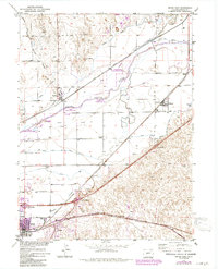
1971 Map of Brush East
USGS Topo · Published 1984About this map
The South Platte River and its accompanying complex of irrigation infrastructure dominate this part of Morgan County, revealing a landscape defined by water management and transit. In this agricultural corridor, a dense network of canals including the Snyder Canal, Sterling Ditch, and Lower Platte and Beaver Canal supports the fertile valley floor. The town of Brush serves as a local hub, anchored by industrial features like the Sugar Refinery and the Municipal Airport. Smaller settlements such as Snyder, Hillrose, and the community at Camden are linked by the Union Pacific and Burlington Northern railroads. Several dedicated wildlife areas, including the Cottonwood State Wildlife Area and Beery State Wildlife Area, preserve the riparian habitat along the river's winding course and the mouth of Beaver Creek. Local education is marked by the Colwell School and Fairview School, reflecting the rural social structure of the mid-20th century.
Find a feature on this map
37 named features on this map. Tap any name to fly to it.
Don’t see what you’re looking for? This feature index may not catch every label — zoom into the map to look around manually.
Map Details
Editions of this 1971 Brush East Map
2 editions found
Other maps of this area

1951 · Dead Horse Springs
USGS Topo · 1:24,000

1951 · Messex
USGS Topo · 1:24,000

1951 · Brush West
USGS Topo · 1:24,000

1951 · Antelope Springs
USGS Topo · 1:24,000

1951 · Merino SW
USGS Topo · 1:24,000

1951 · Brush East
USGS Topo · 1:24,000

1954 · Sterling
USGS Topo · 1:250,000

1958 · Sterling
USGS Topo · 1:250,000

1963 · Round Top
USGS Topo · 1:24,000

1965 · Miller Ranch
USGS Topo · 1:24,000