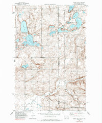
1946 Map of Brush Lake
USGS Topo · Published 1985About this map
Brush Lake Resort and the surrounding prairie wetlands define this landscape along the state boundary where Sheridan Co, Montana meets Williams County, North Dakota. The topography, mapped via planetable surveys in the 1940s, reveals a complex system of glacial kettle lakes including Stink Lake, Twin Lakes, and Horseshoe Lake. The distribution of rural landmarks such as St Olaf Cem and small schoolhouses like Wilson Sch and Liberty Sch reflects the late-stage homesteading patterns of the High Plains. Drainage is dominated by the meandering Cottonwood Creek, which cuts through the southern reaches of the township blocks. The presence of these named water bodies and community nodes suggests a period when local social life was centered around the lake shores and neighborhood schools, even as the larger townships of Grenora and Climax provided the broader geographic framework.
Find a feature on this map
13 named features on this map. Tap any name to fly to it.
Don’t see what you’re looking for? This feature index may not catch every label — zoom into the map to look around manually.
Map Details
Editions of this 1946 Brush Lake Map
3 editions found
Other maps of this area

1946 · Brush Lake
USGS Topo · 1:24,000

1946 · Dagmar
USGS Topo · 1:24,000

1948 · Grenora
USGS Topo · 1:24,000

1948 · Dagmar
USGS Topo · 1:24,000

1948 · Brush Lake
USGS Topo · 1:24,000

1948 · Sunnyhill School
USGS Topo · 1:24,000

1949 · Sunnyhill School
USGS Topo · 1:24,000

1953 · Williston
USGS Topo · 1:250,000

1954 · Wolf Point
USGS Topo · 1:250,000

1957 · Williston
USGS Topo · 1:250,000