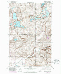
1946 Map of Brush Lake
USGS Topo · Published 1989About this map
Brush Lake Resort sits at the heart of this landscape along the border of Sheridan County, Montana, and Williams County, North Dakota. This survey, based on 1946 topography with later 1980s revisions, illustrates a remote prairie environment defined by alkaline and freshwater basins. The presence of St Olaf Cem and several rural schoolhouses, including Liberty Sch and Woodrow Wilson Sch, provides a clear view of the dispersed settlement patterns common in the northern Great Plains during the mid-twentieth century.
Find a feature on this map
18 named features on this map. Tap any name to fly to it.
Don’t see what you’re looking for? This feature index may not catch every label — zoom into the map to look around manually.
Map Details
Editions of this 1946 Brush Lake Map
3 editions found
Other maps of this area

1946 · Brush Lake
USGS Topo · 1:24,000

1946 · Dagmar
USGS Topo · 1:24,000

1948 · Grenora
USGS Topo · 1:24,000

1948 · Dagmar
USGS Topo · 1:24,000

1948 · Brush Lake
USGS Topo · 1:24,000

1948 · Sunnyhill School
USGS Topo · 1:24,000

1949 · Sunnyhill School
USGS Topo · 1:24,000

1953 · Williston
USGS Topo · 1:250,000

1954 · Wolf Point
USGS Topo · 1:250,000

1957 · Williston
USGS Topo · 1:250,000