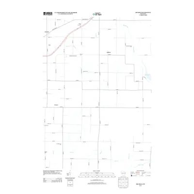
2013 Map of Brussels
USGS Topo · Published 2013About this map
The Niagara Escarpment defines the geological character of this Door County landscape, creating a distinct rise that separates the agricultural plateaus from the lowlands of the Ahnapee River. This 2013 survey illustrates a deeply rooted farming community, centered around settlements like Brussels, Kolberg, and Rosiere. The map reveals a high concentration of dairy and specialized agricultural operations, including Fair Land Dairy, Doorco Farms, and Engebose Farms, reflecting the region’s enduring dependence on the land. Waterways like Silver Creek and the Forestville Flowage provide drainage and recreation, while the road network is marked by descriptive family-named routes. Local landmarks such as Dhuey Hill and the Ahnapee River Tree Farm offer a look at how private land use and topography have shaped the modern rural layout of the Peninsula.
Find a feature on this map
70 named features on this map. Tap any name to fly to it.
Don’t see what you’re looking for? This feature index may not catch every label — zoom into the map to look around manually.
Map Details
Editions of this 2013 Brussels Map
This is the sole edition of this map. No revisions or reprints were ever made.
Other maps of this area

1952 · Casco
USGS Topo · 1:62,500

1954 · Manitowoc
USGS Topo · 1:250,000

1958 · Manitowoc
USGS Topo · 1:250,000

1960 · Sturgeon Bay
USGS Topo · 1:62,500

1960 · Algoma
USGS Topo · 1:62,500

1961 · Little Sturgeon
USGS Topo · 1:62,500

1978 · Casco
USGS Topo · 1:24,000

1978 · Namur
USGS Topo · 1:24,000
1978 · Luxemburg
USGS Topo · 1:24,000

1978 · Brussels
USGS Topo · 1:24,000