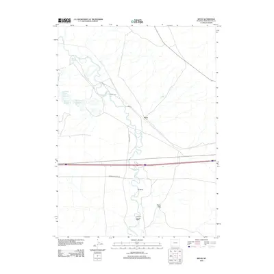
2012 Map of Bryan
USGS Topo · Published 2012About this map
Blacks Fork meanders through this portion of Sweetwater County, defining the drainage patterns and historical transportation corridors of the high desert. This 2012 survey documents the intersection of modern infrastructure and industrial activity, notably the industrial water management sites like Number 2 Evaporation Reservoir and the Solid Waste Disposal Cell E Reservoir in the western reaches. The settlement of Bryan sits near the river's path, connected by a network of ranch and access roads such as Bryan Rd and Lozier Ranch Rd. Topographical features such as The Bluffs and Beacon Light Hill rise above the surrounding terrain, overlooking the seasonal drainage of Meadow Springs Wash. Private holdings like the Pierotto Ranch represent the enduring agricultural and ranching presence in this arid landscape.
Find a feature on this map
14 named features on this map. Tap any name to fly to it.
Don’t see what you’re looking for? This feature index may not catch every label — zoom into the map to look around manually.
Map Details
Editions of this 2012 Bryan Map
This is the sole edition of this map. No revisions or reprints were ever made.
Other maps of this area

1954 · Rock Springs
USGS Topo · 1:250,000
1957 · Mc Kinnon Junction
USGS Topo · 1:62,500

1958 · Rock Springs
USGS Topo · 1:250,000
1961 · Blue Point
USGS Topo · 1:24,000
1961 · Little America
USGS Topo · 1:24,000
1961 · Peru
USGS Topo · 1:24,000
1961 · Austin Ranch
USGS Topo · 1:24,000
1961 · Stevens Flat
USGS Topo · 1:24,000
1961 · Bryan
USGS Topo · 1:24,000

1962 · Rock Springs
USGS Topo · 1:250,000