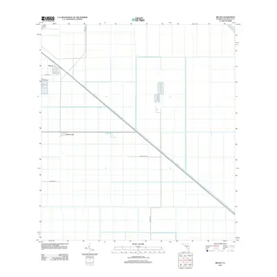
2012 Map of Bryant
USGS Topo · Published 2012About this map
Agricultural infrastructure and water management define this portion of Palm Beach County, where the West Palm Beach Canal cuts a sharp diagonal across the landscape. The settlement of Bryant sits at the northern end of this reach, while further south, Pelican Lake marks a node of activity in an otherwise rectilinear grid of fields and drainage canals. This region is a testament to the industrial-scale reclamation of the Everglades for sugar and vegetable production during the early 21st century. Grounded by a strictly planned network of thoroughfares like Hatton Hwy and Osceola Mill Rd, the map reveals the precise geometry of South Florida's inland economy, where small labor settlements and processing sites are linked by miles of irrigation works and private access roads.
Find a feature on this map
8 named features on this map. Tap any name to fly to it.
Don’t see what you’re looking for? This feature index may not catch every label — zoom into the map to look around manually.
Map Details
Editions of this 2012 Bryant Map
This is the sole edition of this map. No revisions or reprints were ever made.
Other maps of this area

1956 · West Palm Beach
USGS Topo · 1:250,000

1957 · West Palm Beach
USGS Topo · 1:250,000

1958 · West Palm Beach
USGS Topo · 1:250,000

1970 · Belle Glade
USGS Topo · 1:24,000

1970 · West Palm Beach 2 SW
USGS Topo · 1:24,000

1970 · Loxahatchee NW
USGS Topo · 1:24,000

1970 · Pahokee
USGS Topo · 1:24,000

1970 · Bryant
USGS Topo · 1:24,000

1970 · Sixmile Bend
USGS Topo · 1:24,000
1970 · West Palm Beach 2 NW
USGS Topo · 1:24,000