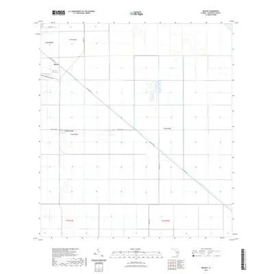
2021 Map of Bryant
USGS Topo · Published 2021About this map
The agricultural landscape of Palm Beach County is defined here by the diagonal course of the West Palm Beach Canal, an essential piece of South Florida water management. The settlement of Bryant sits near the canal's northwestern bend, joined by Canal Point and Pelican Lake in a region historically dominated by the reclamation of the Everglades for sugar and vegetable production. The geometric grid of the Public Land Survey System, marked by township and range lines like t42s r37e, illustrates the systematic division of these fertile muck lands. A network of straight-line roads, including Old Conners Rd and Muck City Rd, provides the infrastructure for transporting crops from the fields to regional markets. This 2021 survey reflects the enduring importance of drainage and irrigation systems in maintaining the habitability and productivity of this low-lying territory.
Find a feature on this map
14 named features on this map. Tap any name to fly to it.
Don’t see what you’re looking for? This feature index may not catch every label — zoom into the map to look around manually.
Map Details
Editions of this 2021 Bryant Map
This is the sole edition of this map. No revisions or reprints were ever made.
Other maps of this area

1956 · West Palm Beach
USGS Topo · 1:250,000

1957 · West Palm Beach
USGS Topo · 1:250,000

1958 · West Palm Beach
USGS Topo · 1:250,000

1970 · Belle Glade
USGS Topo · 1:24,000

1970 · West Palm Beach 2 SW
USGS Topo · 1:24,000

1970 · Loxahatchee NW
USGS Topo · 1:24,000

1970 · Pahokee
USGS Topo · 1:24,000

1970 · Bryant
USGS Topo · 1:24,000

1970 · Sixmile Bend
USGS Topo · 1:24,000
1970 · West Palm Beach 2 NW
USGS Topo · 1:24,000