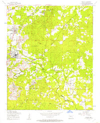
1954 Map of Bryant
USGS Topo · Published 1957About this map
Alexander Mountain and the surrounding landscape of Saline County reflect a mid-century period of industrial mining and rural community life. The western portion of the map is dominated by the extensive Open pit mines and facilities near Pine Haven and Lignite, supported by the Bauxite & Northern RR. This industrial activity stands in contrast to the northern slopes where the Thomas McRae Tuberculosis Home and a Lookout tower overlook the terrain.
Find a feature on this map
50 named features on this map. Tap any name to fly to it.
Don’t see what you’re looking for? This feature index may not catch every label — zoom into the map to look around manually.
Map Details
Editions of this 1954 Bryant Map
3 editions found
Other maps of this area

1890 · Benton
USGS Topo · 1:125,000

1891 · Little Rock
USGS Topo · 1:125,000

1893 · Little Rock
USGS Topo · 1:125,000

1894 · Benton
USGS Topo · 1:125,000

1935 · Little Rock
USGS Topo · 1:24,000

1935 · Alexander
USGS Topo · 1:48,000

1938 · Benton
USGS Topo · 1:48,000

1941 · Alexander
USGS Topo · 1:62,500

1944 · Benton
USGS Topo · 1:62,500

1944 · Alexander
USGS Topo · 1:31,680