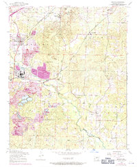
1954 Map of Bryant
USGS Topo · Published 1971About this map
Industrial bauxite mining and the Missouri Pacific rail corridor dominate this mid-century landscape south of Alexander Mountain. In the township of Bauxite, a complex network of open pit mines and expansive tailings ponds illustrates the area's significance to the aluminum industry. The map captures established communities like Bryant and Sardis, while also documenting the Thomas McRae Tuberculosis Home north of the hills.
Find a feature on this map
52 named features on this map. Tap any name to fly to it.
Don’t see what you’re looking for? This feature index may not catch every label — zoom into the map to look around manually.
Map Details
Editions of this 1954 Bryant Map
3 editions found
Other maps of this area

1890 · Benton
USGS Topo · 1:125,000

1891 · Little Rock
USGS Topo · 1:125,000

1893 · Little Rock
USGS Topo · 1:125,000

1894 · Benton
USGS Topo · 1:125,000

1935 · Little Rock
USGS Topo · 1:24,000

1935 · Alexander
USGS Topo · 1:48,000

1938 · Benton
USGS Topo · 1:48,000

1941 · Alexander
USGS Topo · 1:62,500

1944 · Benton
USGS Topo · 1:62,500

1944 · Alexander
USGS Topo · 1:31,680