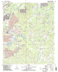
1987 Map of Bryant
USGS Topo · Published 1987About this map
Mining operations and evolving transport routes dominate this mid-1980s look at Bryant and its surrounding communities. Extensive extractive areas and Mine sites are concentrated west of Hurricane Creek, where numerous tailings ponds and levees indicate a landscape heavily reshaped by the bauxite and gravel industries. To the north, the growing residential footprints of Woodland Hills and Shannon Hills sit near the base of Alexander Mountain, while the southern reaches remain more rural, dotted with country churches like Plainview Ch and Sardis Ch. The presence of the Old Grade Railroad Road and the Pacific Union Railroad illustrates the historical reliance on rail for moving heavy minerals, while family-named landmarks like McPherson Cemetery and the Ben Ball Bridge over Hurricane Creek offer vital anchor points for genealogists researching local Saline County history.
Find a feature on this map
65 named features on this map. Tap any name to fly to it.
Don’t see what you’re looking for? This feature index may not catch every label — zoom into the map to look around manually.
Map Details
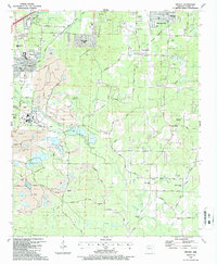
Editions of this 1987 Bryant Map
2 editions found
Other maps of this area

1890 · Benton
USGS Topo · 1:125,000

1891 · Little Rock
USGS Topo · 1:125,000

1893 · Little Rock
USGS Topo · 1:125,000

1894 · Benton
USGS Topo · 1:125,000

1935 · Little Rock
USGS Topo · 1:24,000

1935 · Alexander
USGS Topo · 1:48,000

1938 · Benton
USGS Topo · 1:48,000

1941 · Alexander
USGS Topo · 1:62,500

1944 · Benton
USGS Topo · 1:62,500

1944 · Alexander
USGS Topo · 1:31,680