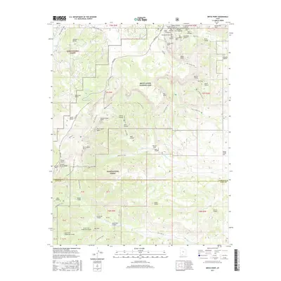
2017 Map of Bryce Point
USGS Topo · Published 2017About this map
Pink Cliffs dominate the eastern topography of this region, where the high elevations of Bryce Canyon National Park meet the timbered reaches of Dixie National Forest. This 2017 survey captures a landscape defined by dramatic geological formations and a sophisticated network of backcountry trails. Along the eastern rim, distinctive landmarks such as Bryce Point, the Natural Bridge, and the Hat Shop overlook deep drainages like Death Hollow and Buldog Hollow. To the west, the Whiteman Bench and Johnson Hollow provide a stark contrast to the sharp breaks of Swamp Canyon Butte and Noon Canyon Butte.
Find a feature on this map
84 named features on this map. Tap any name to fly to it.
Don’t see what you’re looking for? This feature index may not catch every label — zoom into the map to look around manually.
Map Details
Editions of this 2017 Bryce Point Map
This is the sole edition of this map. No revisions or reprints were ever made.
Other maps of this area
1886 · Kanab
USGS Topo · 1:250,000
1953 · Cedar City
USGS Topo · 1:250,000
1958 · Cedar City
USGS Topo · 1:250,000
1962 · Cedar City
USGS Topo · 1:250,000
1966 · Bull Valley Gorge
USGS Topo · 1:24,000
1966 · Cannonville
USGS Topo · 1:24,000
1966 · Wilson Peak
USGS Topo · 1:24,000
1966 · Bryce Canyon
USGS Topo · 1:24,000
1966 · Podunk Creek
USGS Topo · 1:24,000
1966 · Tropic Canyon
USGS Topo · 1:24,000