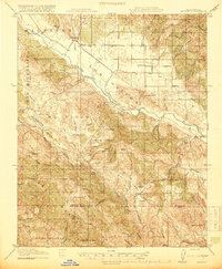
1919 Map of Bryson
USGS Topo · Published 1919About this map
The San Antonio River and Nacimiento River dominate this Central Coast landscape, carving through the Coast Range on the boundary of Monterey and San Luis Obispo counties. In the years following the Great War, this region remained a collection of ranching outposts and small community hubs like Jolon, Lockwood, and Bryson. The map reveals a highly localized infrastructure of rural education, featuring the Pinkerton, Hesperia, and Hoyt schools serving the scattered families of the valleys.
Find a feature on this map
58 named features on this map. Tap any name to fly to it.
Don’t see what you’re looking for? This feature index may not catch every label — zoom into the map to look around manually.
Map Details
Editions of this 1919 Bryson Map
5 editions found
Other maps of this area

1912 · San Ardo
USGS Topo · 1:31,680

1915 · Priest Valley
USGS Topo · 1:125,000

1919 · King City
USGS Topo · 1:62,500

1919 · Junipero Serra
USGS Topo · 1:62,500

1919 · Bryson
USGS Topo · 1:62,500

1919 · Bradley
USGS Topo · 1:62,500

1919 · Adelaida
USGS Topo · 1:62,500

1919 · Piedras Blancas
USGS Topo · 1:62,500

1919 · San Simeon
USGS Topo · 1:62,500

1921 · Cape San Martin
USGS Topo · 1:62,500