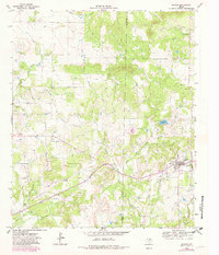
1964 Map of Bryson
USGS Topo · Published 1982About this map
Bryson serves as the focal point of this North Texas landscape, where the local economy in the early 1960s is clearly defined by petroleum and infrastructure. The town's layout includes a High Sch, a Refinery, and a Sewage Disposal facility, while an Old Railroad Grade suggests the evolution of transportation in the region. To the north and west, the Knox Oil Field is marked by numerous Oil Wells, illustrating the intensity of resource extraction during this period.
Find a feature on this map
23 named features on this map. Tap any name to fly to it.
Don’t see what you’re looking for? This feature index may not catch every label — zoom into the map to look around manually.
Map Details
Editions of this 1964 Bryson Map
2 editions found
Other maps of this area

1924 · Graham 4-d
USGS Topo · 1:48,000

1927 · Graham
USGS Topo · 1:62,500

1954 · Wichita Falls
USGS Topo · 1:250,000

1958 · Wichita Falls
USGS Topo · 1:250,000

1964 · Senate
USGS Topo · 1:24,000

1964 · Loving
USGS Topo · 1:24,000

1964 · Bryson
USGS Topo · 1:24,000

1964 · Lake Eddleman
USGS Topo · 1:24,000

1964 · Lynn Creek
USGS Topo · 1:24,000
1964 · Markley
USGS Topo · 1:24,000