
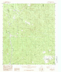
2010 Map of Buck Bay
USGS Topo · Published 2010About this map
Sam Rayburn Reservoir dominates this East Texas landscape, its intricate shoreline defining the geography of San Augustine County in the early 21st century. The map centers on the small community of Parkway, located near the San Augustine Park Campground. The irregular fingers of the lake are fed by numerous tributaries, including Caney Creek, Buck Branch, and Sandy Creek.
Find a feature on this map
35 named features on this map. Tap any name to fly to it.
Don’t see what you’re looking for? This feature index may not catch every label — zoom into the map to look around manually.
Map Details
Editions of this 2010 Buck Bay Map
This is the sole edition of this map. No revisions or reprints were ever made.
Other maps of this area

1953 · Alexandria
USGS Topo · 1:250,000

1953 · Palestine
USGS Topo · 1:250,000

1955 · Alexandria
USGS Topo · 1:250,000

1957 · Palestine
USGS Topo · 1:250,000

1957 · Brookeland
USGS Topo · 1:62,500

1958 · Hemphill
USGS Topo · 1:62,500

1958 · Mc Gee Bend
USGS Topo · 1:62,500

1958 · Bronson
USGS Topo · 1:62,500

1969 · Brookeland
USGS Topo · 1:62,500
1984 · Harrisburg
USGS Topo · 1:24,000