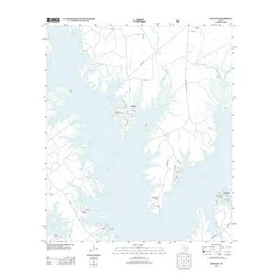
2013 Map of Buck Bay
USGS Topo · Published 2013About this map
Sam Rayburn Reservoir dominates this landscape, its expansive waters and intricate shoreline shaping the settlement patterns of East Texas in the early 21st century. The map reveals how local infrastructure adapts to the reservoir, with recreation hubs like the San Augustine Park Campground and Mill Creek Park Campground positioned along the waterfront. Settlement is concentrated in small communities such as Parkway and Brookland, while family history is preserved in numerous scattered burial grounds including Lakey Cem, Miller Cem, and William's Cem. Distinctive landforms such as Needmore Point and Powell Point reach into the water, surrounded by a dense network of tributaries like Indian Camp Br and Massey-Good Br. This survey provides a precise record of the shoreline and rural road network during a period of established lakeside residence and recreation.
Find a feature on this map
56 named features on this map. Tap any name to fly to it.
Don’t see what you’re looking for? This feature index may not catch every label — zoom into the map to look around manually.
Map Details
Editions of this 2013 Buck Bay Map
This is the sole edition of this map. No revisions or reprints were ever made.
Other maps of this area

1953 · Alexandria
USGS Topo · 1:250,000

1953 · Palestine
USGS Topo · 1:250,000

1955 · Alexandria
USGS Topo · 1:250,000

1957 · Palestine
USGS Topo · 1:250,000
1957 · Brookeland
USGS Topo · 1:62,500
1958 · Hemphill
USGS Topo · 1:62,500
1958 · Mc Gee Bend
USGS Topo · 1:62,500
1958 · Bronson
USGS Topo · 1:62,500
1969 · Brookeland
USGS Topo · 1:62,500
1984 · Harrisburg
USGS Topo · 1:24,000