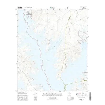
2016 Map of Buck Bay
USGS Topo · Published 2016About this map
Sam Rayburn Reservoir dominates this landscape, where the waters of the Angelina River flooded the piney woods of East Texas to create a complex shoreline of inlets and points. The reservoir forms a massive liquid border between the Angelina National Forest to the west and the Sabine National Forest to the east. Amidst this federally protected timberland, the map reveals traces of older family and community ties through numerous small burial grounds, including Hines Cem, Blackland Cem, and Lakey Cem. Near the southern edge of the sheet, the settlement of Brookeland sits adjacent to the junction of San Augustine, Sabine, and Jasper counties. The terrain is defined by low-lying drainages like Indian Camp Br and Pigeon Roost Cr, which feed into the primary reservoir, creating prominent features such as Needmore Point and Powell Point.
Find a feature on this map
53 named features on this map. Tap any name to fly to it.
Don’t see what you’re looking for? This feature index may not catch every label — zoom into the map to look around manually.
Map Details
Editions of this 2016 Buck Bay Map
This is the sole edition of this map. No revisions or reprints were ever made.
Other maps of this area

1953 · Alexandria
USGS Topo · 1:250,000

1953 · Palestine
USGS Topo · 1:250,000

1955 · Alexandria
USGS Topo · 1:250,000

1957 · Palestine
USGS Topo · 1:250,000

1957 · Brookeland
USGS Topo · 1:62,500

1958 · Hemphill
USGS Topo · 1:62,500

1958 · Mc Gee Bend
USGS Topo · 1:62,500

1958 · Bronson
USGS Topo · 1:62,500

1969 · Brookeland
USGS Topo · 1:62,500
1984 · Harrisburg
USGS Topo · 1:24,000