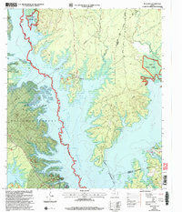
2003 Map of Buck Bay
USGS Topo · Published 2004About this map
The expansive waters of the Sam Rayburn Reservoir dominate this East Texas landscape, where the inundated valley of Ayish Bayou meets the piney woods. Published in the early 2000s, this survey reflects the recreational and natural resource management of the region, specifically where the Angelina National Forest and Sabine National Forest converge. The intricate shoreline is defined by numerous inlets and points, including the distinct Five Fingers and Needmore Point.
Find a feature on this map
34 named features on this map. Tap any name to fly to it.
Don’t see what you’re looking for? This feature index may not catch every label — zoom into the map to look around manually.
Map Details
Editions of this 2003 Buck Bay Map
This is the sole edition of this map. No revisions or reprints were ever made.
Other maps of this area

1953 · Alexandria
USGS Topo · 1:250,000

1953 · Palestine
USGS Topo · 1:250,000

1955 · Alexandria
USGS Topo · 1:250,000

1957 · Palestine
USGS Topo · 1:250,000

1957 · Brookeland
USGS Topo · 1:62,500

1958 · Hemphill
USGS Topo · 1:62,500

1958 · Mc Gee Bend
USGS Topo · 1:62,500

1958 · Bronson
USGS Topo · 1:62,500

1969 · Brookeland
USGS Topo · 1:62,500
1984 · Harrisburg
USGS Topo · 1:24,000