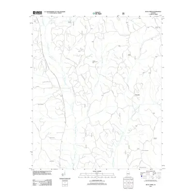
2011 Map of Buck Creek
USGS Topo · Published 2011About this map
Oakmulgee Creek and its many tributaries, including Fivemile Branch and Little Pryor Creek, dominate this rural landscape in Dallas County. The settlement of Panhandle sits on the eastern side of the map, surrounded by a network of family-named roads and burial grounds that speak to the area's deep genealogical roots. Numerous cemeteries are scattered throughout the territory, such as Hepzibah Cemetery, Lovelady Cemetery, and Williams Cemetery, often located near crossroads or along older routes like Fannie Bell Morton Rd and Poplar Grove Church Rd.
Find a feature on this map
29 named features on this map. Tap any name to fly to it.
Don’t see what you’re looking for? This feature index may not catch every label — zoom into the map to look around manually.
Map Details
Editions of this 2011 Buck Creek Map
This is the sole edition of this map. No revisions or reprints were ever made.
Other maps of this area

1891 · Clanton
USGS Topo · 1:125,000

1953 · Montgomery
USGS Topo · 1:250,000

1956 · Montgomery
USGS Topo · 1:250,000

1957 · Montgomery
USGS Topo · 1:250,000

1959 · Plantersville
USGS Topo · 1:62,500

1959 · Summerfield
USGS Topo · 1:62,500

1971 · Maplesville West
USGS Topo · 1:24,000

1975 · Summerfield SW
USGS Topo · 1:24,000
1975 · Plantersville SW
USGS Topo · 1:24,000
1975 · Summerfield SE
USGS Topo · 1:24,000