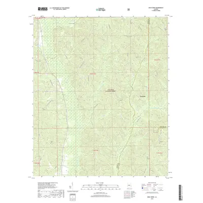
2018 Map of Buck Creek
USGS Topo · Published 2018About this map
Talladega National Forest encompasses much of this landscape at the intersection of Perry, Chilton, and Dallas counties. The terrain is defined by the winding course of Oakmulgee Cr and its many tributaries, including Fivemile Br and Little Oakmulgee Cr, which carve through the dense woodlands. The small community of Panhandle serves as a local point of reference in an area otherwise characterized by timberland and isolated family burial grounds.
Find a feature on this map
41 named features on this map. Tap any name to fly to it.
Don’t see what you’re looking for? This feature index may not catch every label — zoom into the map to look around manually.
Map Details
Editions of this 2018 Buck Creek Map
This is the sole edition of this map. No revisions or reprints were ever made.
Other maps of this area

1891 · Clanton
USGS Topo · 1:125,000

1953 · Montgomery
USGS Topo · 1:250,000

1956 · Montgomery
USGS Topo · 1:250,000

1957 · Montgomery
USGS Topo · 1:250,000

1959 · Plantersville
USGS Topo · 1:62,500

1959 · Summerfield
USGS Topo · 1:62,500

1971 · Maplesville West
USGS Topo · 1:24,000

1975 · Summerfield SW
USGS Topo · 1:24,000
1975 · Plantersville SW
USGS Topo · 1:24,000
1975 · Summerfield SE
USGS Topo · 1:24,000