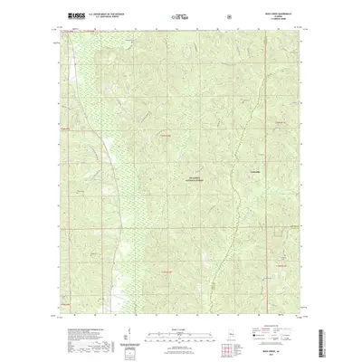
2021 Map of Buck Creek
USGS Topo · Published 2021About this map
The Talladega National Forest dominates this central Alabama landscape, where the borders of Perry, Chilton, and Dallas counties converge. This 2021 survey reveals a territory defined by complex creek networks and scattered rural landmarks. The settlement of Panhandle sits near the eastern edge, surrounded by family-named cemeteries that provide essential clues for genealogical research. These include Lovelady Cem, Medline Cem, and Williams Cem, often located near winding forest roads like Old Oak Grove Church Rd. Significant watercourses such as Oakmulgee Cr and Little Oakmulgee Cr drain the timbered ridges, while several local connectors like Charlie Perry Rd and Dallas Co 272 weave through the forest tracts, marking the enduring footprint of rural residency within the federally managed lands.
Find a feature on this map
51 named features on this map. Tap any name to fly to it.
Don’t see what you’re looking for? This feature index may not catch every label — zoom into the map to look around manually.
Map Details
Editions of this 2021 Buck Creek Map
This is the sole edition of this map. No revisions or reprints were ever made.
Other maps of this area

1891 · Clanton
USGS Topo · 1:125,000

1953 · Montgomery
USGS Topo · 1:250,000

1956 · Montgomery
USGS Topo · 1:250,000

1957 · Montgomery
USGS Topo · 1:250,000

1959 · Plantersville
USGS Topo · 1:62,500

1959 · Summerfield
USGS Topo · 1:62,500

1971 · Maplesville West
USGS Topo · 1:24,000

1975 · Summerfield SW
USGS Topo · 1:24,000
1975 · Plantersville SW
USGS Topo · 1:24,000
1975 · Summerfield SE
USGS Topo · 1:24,000