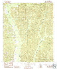
1987 Map of Buck Creek
USGS Topo · Published 1987About this map
Talladega National Forest encompasses the majority of this landscape, where the confluence of three Alabama counties—Perry, Dallas, and Chilton—creates a complex network of administrative and geographical boundaries. The terrain is defined by a dense system of waterways, most notably Oakmulgee Creek and its various tributaries like Oakmulgee Branch and Little Fivemile Branch. In the late 1980s, this area remained largely rural and undeveloped, with small concentrations of activity centered around Fullers in the northwest and Panhandle in the east. Economic activity is subtly noted by a Gravel Pit near the headwaters of Osborn Creek, suggesting a reliance on local natural resources. The map captures a moment when the forest boundaries and local creek-fed valleys dictated the movement and settlement patterns of this multi-county intersection.
Find a feature on this map
16 named features on this map. Tap any name to fly to it.
Don’t see what you’re looking for? This feature index may not catch every label — zoom into the map to look around manually.
Map Details
Editions of this 1987 Buck Creek Map
This is the sole edition of this map. No revisions or reprints were ever made.
Other maps of this area

1891 · Clanton
USGS Topo · 1:125,000

1953 · Montgomery
USGS Topo · 1:250,000

1956 · Montgomery
USGS Topo · 1:250,000

1957 · Montgomery
USGS Topo · 1:250,000

1959 · Plantersville
USGS Topo · 1:62,500

1959 · Summerfield
USGS Topo · 1:62,500

1971 · Maplesville West
USGS Topo · 1:24,000

1975 · Summerfield SW
USGS Topo · 1:24,000
1975 · Plantersville SW
USGS Topo · 1:24,000
1975 · Summerfield SE
USGS Topo · 1:24,000